Antenna Coverage Program (ACP)
Generate maps for stalleite coverage design, planning, and marketing
Visualize maps of satellite characteristics as well as carrier performance
Customize the look and feel of bean pattern maps in 2-D and 3-D projections
Design coverage options for various satellite locations, orbits, and bean pointings
About ACP
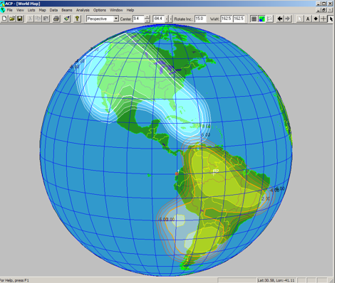
The Antenna Coverage Program (ACP) is a general purpose, full-featured software tool for satellite antenna coverage mapping and visualization. It has the capability to generate and plot all types of coverage maps required for accurate visualization of spacecraft performance and planning and management of the space segment. ACP is a sophisticated graphics program with a modern graphical user interface, and presentation quality full-color fully-user-customizable graphics. ACP is integrated with Enterprise Capacity Manager (ECM) and Complan.
ACP is used by systems engineers, antenna designers, and marketing specialists to perform a wide variety of functions, such as comparing and assessing satellite coverage areas, examining the effects on coverage of a satellite in inclined orbit, performing coverage availability analysis using rain statistics, and planning the location of a new satellite.
Benefits
– Design complex coverage with ease
– Plan with confidence accounting for worst-case antenna patterns and pointing errors
– Evaluate existing coverage to optimize ground networks
– Track a variety of performance characteristics
– Generate customized pattern coverage images
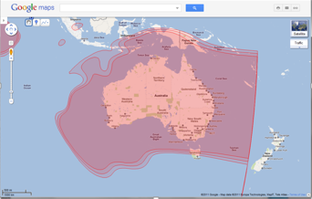
– Integrate coverage pattern data with Google Earth, Maps, and ECM
Major Features
Facilitates Technical Modeling and Scenario Analysis
Produces Accurate Presentation Quality Graphics
Intuitive to Use and Integrated with the Industry
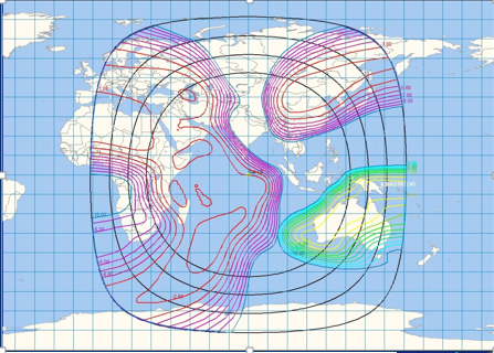
– Generates and displays satellite antenna coverage beams based on analytical antenna models for circular and elliptical beams
– Generates error boxes or worst-case antenna patterns to account for pointing errors
– Accounts for path loss and displays power flux density contours
– Displays co-pol and cross-pol coverage pattern contours based on antenna measured data
– Tabulates gain, look angles, and pattern advantage for any earth station location
– Plots cities and earth stations. Allows import of cities from spreadsheets and lists
– Accesses a variety of performance characteristics such as: polarization isolation, gain, G/T, SFD, and EIRP
– Draws contours of constant elevation or azimuth angle for any satellite position
– Displays coverage from singular contours to entire beam patterns
– Plots satellite locations, earth stations, and antenna patterns as viewed from an arbitrary location
– Supports several map projections – orthographic, perspective, equirectangular, and Mercator
– Includes up-to-date world map features with continents, countries, US states, lakes, rivers, seas, and oceans
– Plots cities and earth stations. Allows import of cities from spreadsheets and lists
– Provides full control of drawing styles, tilting, text labels, colors, features, etc. for presentations and artwork. Exports graphics in several formats
– Allows zooming, beam repointing, etc. via drag-and-drop user interaction or precise placement using text fields
– Supports quick static and steerable beam re-projection due to changes in spacecraft location, inclination, or bias
– Saves multiple user preferences for map displays, and the settings of various colors, default projections, grid lines, etc.
– Exports contour data to GXT format – for ITU coordination and use with GIMS, SatManage, iDirect Beam Switching, etc.
– Exports to Google Earth and Google Maps and common file formats such as Bitmap, JPEG, and TIFF
– Supports satellite antenna design engineers who use SATSOFT. Pattern files in most other formats (e.g., GRASP, TICRA, etc.) can be easily converted to the correct format by Optimal Satcom
ACP is seamlessly integrated with both ECM and Complan, and is used by both programs to display maps and map-based results.
The Antenna Coverage Program (ACP) is available as a stand-alone program, or comes bundled with ECM and Complan, and runs on Windows 10/11.
ACP is licensed based on number of concurrent users. It may be procured either as a perpetual license (CAPEX), or an annual license (OPEX). Perpetual licenses include one year of software upgrade, maintenance, and technical support. Support for perpetual licenses may be renewed annually after the first year. Annual licenses include support, and are required to be renewed annually to continue using the software. It also comes included bundled with ECM and Complan. If you have procured ECM or Complan, you will probably not need to procure ACP separately.